Friday, October 20, 2017

Queenstown trip

We recently spent a long weekend with friends near Queenstown. Not one photo taken in Queenstown but some great photo opportunities on the way down and home again.

Stopping before the visitor centre at Lake Pukaki, high above the lake, I found this spot to frame Mt Cook and away from the hordes of tourists taking their selfies at the visitor centre.

Aoraki, Mt Cook, highest mountain in New Zealand.
From the same spot but at a wider angle.
After stopping in Wanaka it was time to head to Queenstown over the Crown Range. Not the best time of day for photography but a bit of processing on the computer bought up some details in the following.

Cardrona Hotel dating from the 1863 gold rush era.
The short cut from Wanaka to Queenstown is a very popular thing on the "must do" list for visitors. To get this photo (I don't like people cluttering up my photos), one has to exercise considerably patience to let the rush of selfie posing tourists do their thing. Only a 5 minute wait for this one before some else popped into frame.

Cardrona Post Office
The Crown Range is the highest main road in New Zealand as the plaque below shows. On a fine day, the views are spectacular. In winter unsuspecting tourists frequently get into trouble with snow and ice.
The Crown Range summit.
As you can see the sun is in the wrong place late in the afternoon. However with a touch of HDR software, details of the stone have been bought out.


The Arrow River with the road downhill on the left.
Passing through Queenstown without stopping this time, Glenorchy bekoned. On the way back the day had improved and Mt Earnslaw look stunning against the green grass.


Mt Earnslaw. The Dart River flows down the left side with the Rees River joining from the right.
Next photo stop was on the way home at Shag Point. Coal was discovered here in 1862 and mined until 1972. A railway branch line operated from 1879 until 1934.

Shag Point coal tub.


Shag Point has a seal colony, only one home this day but plenty of sea birds. Red billed gulls and terns being the predominant species. The terns were a bit far away but there were some nice groups of gulls to catch in the frame.

Heads into the wind.
Resting, not nesting?

Monday, October 9, 2017

Around Timaru

The imminent demolition of the Hydro Grand Hotel overlooking Caroline Bay in Timaru provided the inspiration to capture some photos of it before it disappeared under the wreckers ball. The following photos resulted from several visits, the first without camera, to the bay area.

PS: There Hydro Grand was demolished on Saturday, 18 November 2017.
The Hydro Grand - not grand anymore.


The vacant spot after the demolition of the Hydro Grand.

More photos of the demolition are here and also part 2.

The following photos were taken earlier in the year!

Hydro Grand and piazza.


Caroline Bay and the Benvenue Cliffs.
On my "first recent" visit(s) to Caroline Bay, I was walking back towards where the car was and thought that there would be a good angle for showing the container cranes, but alas no ship. Another ship was being worked a few days later when I returned to photograph the Hydro Grand.
Returning back to the car in the opposite direction to the Benvenue Cliffs.
An earlier trip to Timaru to photograph the Hydro Grand was late in the afternoon. However the light was poor and no photos then.

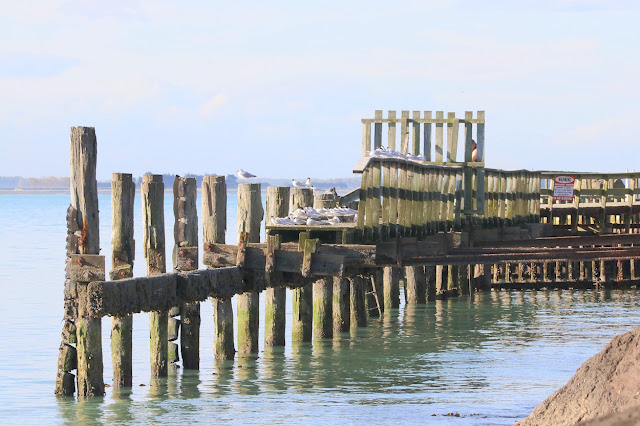
Along the road way, the seagulls were lining up and the old jetty by the yacht club provided some angles for the next two photos.


The old jetty has fallen into disuse as sand has accumulated in Caroline Bay and the shore line marches steadily outwards.
An attempt to photograph the little blue penguins as they come ashore after a day at sea was not successful as flash photography is not allowed. All was not lost however as a container ship turned up.

Around to the Benvenue Cliffs, out with the long lens and tripod and these two working shots were the result.


The Pacific Trader was unloading within 30 minutes.


Blackett's Lighthouse was originally built in 1878 at  No7 Terrace and was visible 14 nautical miles out to sea. It was decommissioned in 1970 and moved to the Benvenue Cliff site in 1970 where it served as the rear leading beacon to the Timaru Harbour until 1980. It was moved again in 2010 and restored.

Blackett's Lighthouse


Fun with burning steel wool down on the beach.


Tuesday, August 8, 2017

Fun car rally

Recently, Focus Aorangi had a mystery car rally starting in Pleasant Point. We were given some clues and were tasked too the a photo of each place where we were to go to. Below are photos of each place / object / building etc that we had to get.

The clues of what to photograph and photos I took are as follows: (Directions to get to each clue omitted.)

1. If you are really Keane turn right into this road and you will find some cobs that aren't corny. If you ascend too much you've gone too far. 

The restored cob cottage at the bottom of the hill in Keanes Road.
2. A building that houses levers used for signalling.

The signal box showing the tops of the levers, Pleasant Point Railway Museum.


3. Initially used for Government purposes, this building turned to custard. 

The former Pleasant Point Post Office, converted to a cafe and home to Denheath Custard Squares.

4. At the dead centre of Pleasant Point this building has interesting detail in its boarded up windows.

Small building at the Pleasant Point Cemetery.

5. Towering above us, this ecclesiastical structure points into the wind.

Earthquake damaged church points directly towards the nor'west.

6. Three timeless faces overlooks the railway station.

The tower at another earthquake damaged church in Pleasant Point.


7. Does this place or worship ring a bell?

The bell rings every Sunday morning at St Albans Anglican Church. Of the three churches in Pleasant Point, St Albans is the only one not damaged by earthquakes since 2010.

8. Along here you will find where an early inventor crashed into a hedge.

The memorial to Richard Pearse who flew a heavier than air machine before the Wright brothers at Kitty Hawk.

9. You will see a heritage structure used to burn something quarried locally.

Top of the lime kiln at Kakahu.

10. Near the end of Cox St you will find, for your comfort, Geraldine's newest public building wrapped in a club member's images.

Rear wall of the public toilets with a huge photo of the nearby native bush.

11. Nearby is one of Geraldine's oldest buildings, built by the Roads Board from basalt. It has since been relocated and purposed to display its heritage.

The Geraldine Museum of a fine autumn afternoon.

12. Previous generations posted letters there. Today it houses as retail outlet and a gallery, but is still a stately building. 

The old Geraldine Post Office. The vintage car happened to come around the corner at a most convenient time.

13. In the grounds is an obelisk or narrow pyramid. A close up of its detail is the final clue.

Part of well-weathered steel pyramid. Note the hint of a cobweb.

The clues were easy but a load of fun in getting there best angle, light etc. for a good photo. (We were also given instructions about where to go in terms of roads etc. Only the cryptic  clues as to what to photograph are given here.)