Wednesday, April 22, 2020

San Francisco

Flying from Flagstaff to San Francisco via Phoenix saw us arriving at our hotel in Fishermans Wharf for nearly a week's stay.


One is spoilt for a choice of things to do and see when based here.

The cable car provided us with the first opportunity to explore San Francisco. 


Ready for departure to Market Street.

Having purchased our day pass at an adjacent kiosk for 23USD we were promptly informed by the conductor that it is only 12USD from him! 

Another day we hired e-bikes and set off over the bridge with a lunch stop at Sausilito in Marin County.


Fort Point


The bike shop told us that we would get 22 miles if we left it on power setting 2. By using the settings when needed we managed a 42 mile ride with over 50% of the battery power left.

After lunch we set off for Mill Valley to visit some giant redwood trees. It was a few miles uphill but the e-bikes came into their own.


Mill Valley redwoods

It was Saturday when we did the bike tour. (Thursday that week was when I went out to Yosemite NP blog). On the way down the valley both our phones received emergency warnings for possible bush fires in Marin County. The wind was expected to increase and that the power might have to be turned off for 2 million customers. More about the fires in October 2019 at the end of this blog.


Biking towards Tiburon for the ferry back to Pier 39 at Fishermans Wharf we were confronted by a steep incline. Using power setting 5, once the pedals were engaged we literally flew up the hill effortlessly. 


The Painted Ladies

A night time tour of Alcatraz (aka "The Rock") produced the opportunity to capture a nice sunset on the way over.


Golden Gate bridge sunset

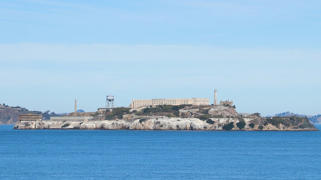
Alcatraz

Alcatraz near the jetty.
 
New inmates to the prison were first given their prison clothes and other items.


Clothing issue store

Towels and toiletries issued here.
Next stop was the shower room.

No privacy in the shower room.


One of the cell blocks

Alcatraz had a maximum number of cells of  over 300. The maximum number of inmates was around 280. It was for the most dangerous prisoners with one riot when a number of guards were shot with stolen weapons. The Battle of Alcatraz took place in May 1946. No executions took place here. 

Al Capone's cell

In June 1962 the only escape from Alcatraz occurred. Frank Morris and the Anglin brothers John and Clarence escaped through holes in the cell walls they had chiselled out and into service tunnels.  Nothing more was ever heard from them, so did they make it or perish in the cold waters of San Francisco Bay? Various theories exist as to what happened them. Certainly the cold water and strong tidal currents meant that a swim to shore would be unlikely to be successful.

Escapee's cell

One the attractions in San Francisco is the extensive maritime museum. I spent most of one day there in brilliant sunshine and clear skies.


Martime Museum 

Pride of place is the last remaining operational of 2,710 Liberty Ships built during WW2, the Jeremiah O'Brien.


Jeremiah O'Brien


Alcatraz through the gunsight of a
20mm Oerlikon anti-aircraft gun on the Jeremiah O'Brien

Sunday 27 October was our last day in San Francisco with breakfast at the sourdough bakery. Next a hop-on-hop off bus tour before heading to the airport for the long flight back to Melbourne then onto Wellington. Whilst at the airport we could see a huge bank of smoke spilling over the hills on the other side of the bay. The bush fires were starting to cause havoc in several parts of California by now. By Monday the whole bay area was choked with smoke. We were lucky to be blessed with fine clear skies and warm temperatures.

Yosemite blog.


Monday, April 20, 2020

Yosemite NP

A long day started off at 6:00am for the pick up near the hotel then it was off after a few pickups to the Yosemite National Park. The first stop on the way was the Tuolumne Grove to see some giant sequoias.


The trees in this grove were never logged because the road down to them was extremely steep. 400 feet down in one mile to the bottom.

On the way down I stopped to take in the dogwoods which were in their fall (autumn) colours.


Reaching the grove at the bottom of the track, the surviving sequoias are truly awe inspiring for their sheer size.


The only way I could get a photo of this tree was with my iPhone and to do as panorama shot. Hence the slightly distorted appearance.

Lightning struck specimen.
I remember seeing a photo of this tree many years ago, with a logging truck in the middle. I had no idea where this was and was surprised see it. After General Sherman, this is probably the most "famous" sequoia.

From here is was on to the Yosemite National Park for our first stop at Tunnel View.

You can see all the photos and videos in online and in brochures, 
but there is nothing like seeing it in person.

This applies to the Grand Canyon and equally well here.

The view from Tunnel View. El Capitan on the left, Half Dome in the centre.
Half Dome.

I found this view to have lunch. Not another soul around. I had this all to myself for about half an hour.

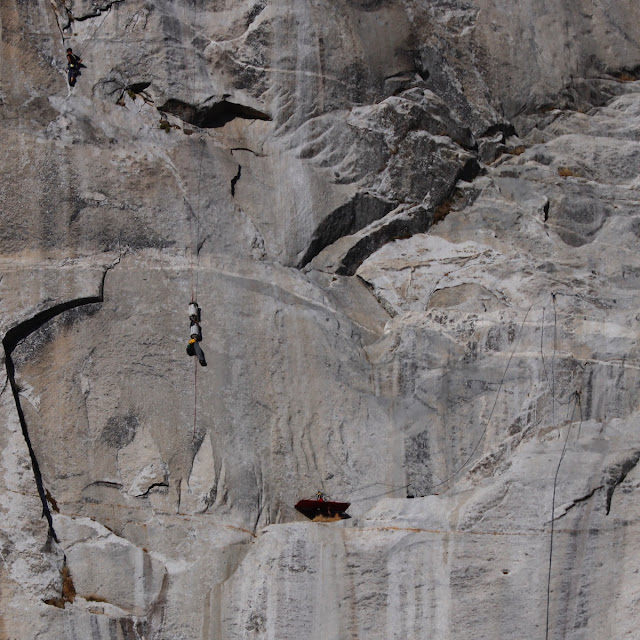
El Capitan, 1,200 m of vertical rock. A climbers mecca.

Reaching for the tripod and long lens, I found some climbers suspended on the face.

Climbers on El Capitan.

One advantage of going on a group trip is that you get taken to some of the best views and the last stop was to be no exception. Pity it was late in the day with shadows from the right though spoiling an otherwise top shot.


Yosemite reflections

After we had got our photos it was time to get back on the bus for the long drive back to San Francisco. On the way back the driver/guide told us that large bush fires in California had resulted in a town of 50,000 being evacuated. We were to catch up with the developing situation 2 days later.

San Francisco blog. 


Wednesday, April 15, 2020

Arizona part 2

Following our trip to the Grand Canyon, the next day's expedition was out to Horseshoe Bend and Antelope Canyon.

Driving out through the Arizona desert we stopped at a small village where there was an outcrop that caught my attention.


Spectacular formation

More rocks, the North Rim above
The carpark had many cars and buses parked. It was a walk of about one and a half miles to one of the geological wonders of the world. 

Approaching Horseshoe Bend

To the left, looking towards downstream of the Colorado River
The path leading down to the bend
- no wonder the car park was full.
The following shot shows the best I could get with my Canon 80D, at 15mm. The bend in the river is 270 degrees making it difficult to fully capture it.


The shadow in the cliff of the left has been lightened as much as possible - I wasn't happy so out came my iPhone for the next shot in panorama.


I think my phone handled the different light better than my camera. I was to find this out a few hours later at Antelope Canyon. (Phone camera do have their place but they are limited in what you can do too.)

Notice the rather low level on the river and hints of green slime.  The cause of this was obvious at our lunch stop next. 


Glen Canyon Dam
If you look on the top left you can see the high water mark. The water in the dam must have been at least 15 or 20 meters below full, hence the low flow of water seen at Horseshoe Bend. (Is this indicating drastic climate change- a megadrought perhaps?)

As a keen photographer, the problem with being on an organised tour is that you don't have time to explore different angles to get the best images. This shot of the dam doesn't show you the magnitude of it. I would have liked to have gone onto the bridge to get a better angle but time did not permit.


The bridge from the same place and the dam shot.
Next stop was Antelope Canyon, one of many in Arizona and neighbouring Utah. Such canyons owe their existence to erosion and in particular the effects of flash floods. Antelope Canyon has many recorded such events


A canyon renown for its narrow, twisting limestone walls became a trap for 12 hikers on Tuesday when a flash flood filled it with a wall of water 11 feet high.
The guide for several of the hikers survived, battered and his clothes ripped off by the force of the water, and the body of one woman was found yesterday. The other 10 are missing and presumed dead.
The storm came without warning. A cloudburst 15 miles away sent heavy runoff down a normally dry wash in Antelope Canyon toward the unsuspecting sightseers. ''Rain had not fallen where they were hiking,'' said Benson Nez, a ranger on the Navajo reservation which the canyon runs through.
New York Times, 14th August 1997.

A survival story of the 1997 flood.


Now days there are steel stair cases at the entrance, exit and at other places in the middle of there canyon. Strategically placed rope ladders are placed in case evacuations are needed. There are also early warning systems in place upstream in case of rising waters. The steel stair cases have been replaced several times bearing testament to the power of rapidly moving moving water. It was fine day when we were there and no hint of rain clouds anywhere!


First view when we got down the stairs.


My phone handled the bright contrast between there sky and the shows in the canyon better than my Canon.
The water worn slot canyon

Photo opportunity courtesy of our Navajo guide.

The seahorse.

Leaving the canyon we passed through Page on our way back to Flagstaff. However there were a few stops on there way.

I couldn't resist requesting to stop and get a shot of this outcrop.


One thing that I noticed was how intensely blue the sky was at the higher altitudes in Arizona. The dry atmosphere helps in the respect too.

A must do on the way back was to visit the Cameron Trading Post. Run by the Navajo, this is a huge post selling a large range of goods aimed primarily at the tourist trade. I could have bought an intricately worked gun holster fo my six shooter and matching cowboy outfit too.

Next stop was San Francisco and Yosemite NP., coming up soon.

Monday, April 13, 2020

Arizona part 1

In October 2019 I had the unexpected opportunity to tick off some items on my bucket list. The Grand Canyon has always been up there as one of the wonders of the world to see. 

My daughter and I were up very early one Thursday morning to catch a 06:45 am flight from Wellington to Sydney. After a few hours wait in SYD we boarded a Qantas A380 for a long flight (15+ hrs) to Dallas(DFW), another wait there before going on to Flagstaff. We arrived at our hotel in Flagstaff around 36 hours after getting up in Wellington - and it was still Thursday!! (Coming back to New Zealand, we skipped a Monday.)

Our first excursion from Flagstaff was a short ride up to the Lowell Observatory

This observatory was financed and built for Percival Lawrence Lowell who predicted the presence of a planet beyond Neptune.


The telescope Percival used in his search for Pluto


The business end where the photographic plate were mounted.
Unfortunately Lowell died in 1916 having not discovered the planet he predicted to exist. 

It was Clyde Tombaugh who finally made the discovery of Pluto in 1930.


The following day we had a tour booked with Canyon Country tours to the Grand Canyon.  Glenn picked us up from our hotel and set off but made a detour on the road up to the Snowball ski field on the side of Mt. Humphries (the highest point in Arizona). Being October, the aspens were in their full fall (autumn) colours.

Golden aspens


Moving on we next stopped at Tusayan, one of the gateways to the Grand Canyon National Park on the South Rim.

Thumbs up for me to tick an item off my bucket list!
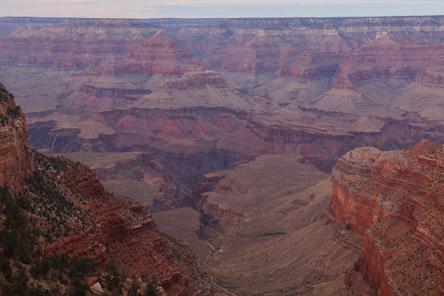
My first sight of the Grand Canyon is, to say the least breath taking! Eventhough I'd seen photos, words failed me to describe my feelings at this truly magnificent geological formation.
Hannah and I ready to get our cameras busy.
(Glenn our guide had mine for this shot.)
Being so high at this point we were amazed at the clarity of the air and that we could see Mt. Navajo, 140 miles away! The North Rim in the photo below is around 28 miles away.
Mt. Navajo on the horizon at the right, 140 miles away.


Most view points give you a 1800 view this huge canyon, all I've managed here are a few shots to give you an idea of the coloured formations and what to expect, should you go there. 


The Colorado River has been busy for the last 2 billion years carving down into rocks that are now about 5,000 feet below the plateau of the South Rim. 


Spot the tree in the cleft of the rocks, Colorado Rover in centre.
Kolb Studio
The Kolb brothers opened a photographic studio here in 1904 which they operated until 1976. In 1911 they successfully navigated the Colorado River which really kicked off the tourism industry. Now their studio contains exhibitions and films of early expeditions on the river. It is also an access point to trails down to the river, 5,000 feet below! 


The watch tower
Last stop of the day was at the watch tower. From the above photo you can see the cloud had built up during the day. This hinted at the possibility that the "golden hour of light" might happen. We were not to be disappointed.

One of the many highlights of the day was the sunset at the tower before we left to go back to Flagstaff via Cameron.


Sunset at the tower
Glenn, our guide for the day, told us that were were extremely lucky in that such sunsets don't occur like this very often - maybe only 20 decent ones per year.

Next day was a trip out to Horseshoe Bend and Antelope Canyon. Arizona part 2 is here now.